


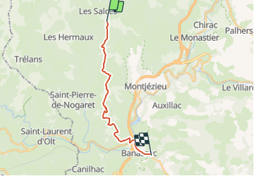
Chemin de St-Guilhem - étape 04 : Col du Trébatut à La Canourgue

cathel11
User

Length
16.3 km

Max alt
1101 m

Uphill gradient
239 m
Km-Effort
21 km

Min alt
523 m

Downhill gradient
767 m
Boucle
No
Creation date :
2021-02-26 20:22:30.325
Updated on :
2022-01-16 19:32:16.078
4h49
Difficulty : Very difficult

FREE GPS app for hiking
 SityTrail
IGN / Geographical institutes
SityTrail Plus
The world is yours!
About
Trail Walking of 16.3 km to be discovered at Occitania, Lozère, Les Salces. This trail is proposed by cathel11.
Positioning
Country:
France
Region :
Occitania
Department/Province :
Lozère
Municipality :
Les Salces
Location:
Unknown
Start:(Dec)
Start:(UTM)
513545 ; 4930389 (31T) N.
Comments